Nederland through Eldora
CR 130
The main modern approach into the old Eldora mining district. It is paved through the town of Eldora.
Public roadEldora, Colorado · Historical road research
A real but unfinished state wagon-road project, a mining corridor that once carried wagons to the Fourth of July Mine, and a high-country grade now absorbed into the Arapaho Pass Trail.
The central finding
The name “Fourth of July Road” now covers—or is casually applied to—a sequence of different corridors: a public county approach, a City-owned campground destination, a wilderness trail to the mine, and the surviving upper grade of an unfinished state road toward Arapaho Pass.
Nederland through Eldora
The main modern approach into the old Eldora mining district. It is paved through the town of Eldora.
Public roadEldora to Buckingham
A rough county-road branch serving the campground and trailhead. Boulder County pages have used both CR 111 and CR 130 labels for portions of this corridor.
Seasonal in realityCampground to mine
A historic mine-access corridor, although the precise overlap between today’s lower trail and former wagon alignments is not fully documented.
NonmotorizedMine to Arapaho Pass
The Forest Service expressly says Trail #904 continues west from the mine “on an old road” for roughly 1.2 miles.
Inside wilderness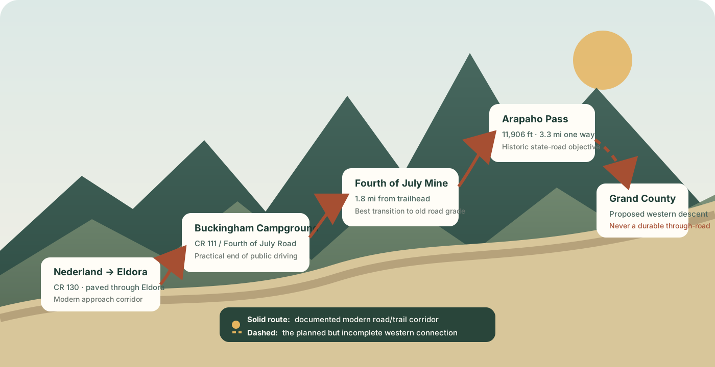
Best-supported interpretation
Wagons were reaching the Fourth of July Mine by 1903, before the principal state construction contracts. The 1905–08 project appears to have improved difficult portions of the Eldora-to-mine corridor and attempted to extend a wagon-grade road from the mine toward—and nominally across—Arapaho Pass. That interpretation is an inference from the dated mine photograph and the State Engineer’s reports, not proof that every foot of the earlier and later alignments was identical. S6 S7 S8
Beyond the gate
The short campground-side road/trail and the high wagon-road grade are not the same thing. The historically important state-road remnant is most clearly identified above the mine.
An older accessible-trails guide documented a disabled parking space near the end-of-road gate, a three-foot opening beside the gate, and a hard-packed crusher-fines-and-dirt route. After approximately 217 feet, a short branch descended toward a creek-bank viewpoint.
Those measurements come from an older guide. Mountain surfaces, barriers and accessibility features can change, so they are not a present-day guarantee.
The Arapaho Pass Trail reaches the Fourth of July Mine at 1.8 miles. From there, the Forest Service specifically identifies the next 1.2 miles toward Arapaho Pass as an “old road.” That official description makes the mine-to-pass section the strongest surviving candidate for the 1906–08 state-road grade.
The complete trailhead-to-pass trip is 3.3 miles one way, rising from about 10,100 feet to 11,906 feet.
History
The documentary record is strongest for the 1903–19 period. Earlier mining dates conflict, and later records do not reveal one simple, formal closure date.
The Indian Peaks and James Peak country lies within the traditional homelands of Nuuchu/Ute, Hinono’ei/Arapaho and Tsistsistas/Cheyenne peoples, who lived, hunted and traveled seasonally through the mountains. No reliable source located for this project tied the precise Fourth of July wagon-road alignment to a specifically documented Indigenous trail, so that connection should not be assumed. S18
Official and quasi-official historical sources do not agree. A Boulder County historic-site survey says C. C. Alvord located the Fourth of July Lode in 1875. A modern Forest Service history, quoted in reporting on mine remediation, places the Independence Day claim and discovery in 1872. The dates may refer to different events—discovery, staking or formal location—but the sources do not reconcile them. S4 S5
An archival photograph shows Joseph “Rocky Mountain Joe” Sturtevant flipping a pancake in front of the Fourth of July Mine, with the high peaks and glacier country behind him. The image captures the overlap of mining, tourism and local mountain culture well before wilderness designation. S16
A dated Boulder Historical Society photograph shows people seated in a wagon in front of upper mine buildings. It is direct visual evidence that substantial wagon access reached the mine before the state’s principal Arapaho Pass construction began in 1906. S6
View the 1903 archival recordThe General Assembly enacted a law for a state road from Boulder County over “Arapahoe Pass,” then into Grand County to connect with the county road between Hot Sulphur Springs and Grand Lake. The historic spelling in the law and engineering reports includes the final “e”; modern maps use “Arapaho Pass.” The appropriation was $5,000. S2 S7
The contemplated route was approximately eight miles from Eldora to the pass and another twelve miles on the Grand County side. Boulder surveyor Horace C. Hall divided the work into sections at Hesse Hill, Denver Hill and from the Fourth of July Mine toward Arapaho Pass. Hendry Johnson received the contract. Early snow halted the season after the lower sections and roughly half of the planned mine-to-pass work were completed.
Grand County permitted the available appropriation to be spent on the Boulder County side rather than reserving half for the west. That decision helps explain why the surviving project is principally an eastern approach rather than a complete trans-Divide road. S7
Johnson completed the work covered by his contract in August 1907. About $1,000 remained. County surveyor A. E. Chase laid out additional work, and C. L. Stewart received an $890 contract in August 1908. Early snow again prevented all planned work from being finished that season. The reports document short construction projects and improvements—not completion of the full Eldora-to-Grand County concept. S8
Roger Toll’s federal mountaineering guide said a traveler could walk, ride or drive from Eldora to the Fourth of July Mine. The pass lay about another mile and a half beyond, but the wagon road started over it had been abandoned. This is strong evidence that mine access remained normal while the upper road had already ceased to function as a maintained vehicular route. S9
The mine was never among the district’s largest producers. Silver dominated early activity, with later interest in copper. The Forest Service history summarized in modern reporting says the operation was abandoned in 1937. S5
Mr. and Mrs. Carl E. Buckingham donated approximately 35 acres near Eldora to the City of Boulder for a campground. The City continues to operate the small campground, while the adjoining wilderness trailhead and upper trails are administered under different jurisdictions. S3 S19
Congress designated Indian Peaks Wilderness in 1978. Wilderness rules now prohibit ordinary motorized equipment and mechanized transportation on the upper route; wheelchairs are exempt from that prohibition. S11
Congress added approximately 963 acres of federal land identified in legislative materials as the Fourth of July Addition to Indian Peaks Wilderness. S17
Crews sealed a dangerous shaft reported to be about 300 feet deep. With helicopters and ordinary machinery constrained by wilderness management, nine horses made three trips carrying 150 bags of polyurethane foam roughly two miles and 1,000 vertical feet to the site. S5
Ownership and jurisdiction
“Who owns the road?” has no single answer. Road-management status, fee ownership of the ground, public rights-of-way, mining claims and wilderness administration are different legal questions.
CR 130 runs from Nederland through Eldora. Beyond the Hessie-area junction, official naming is inconsistent: the County’s Hessie page calls Fourth of July Road CR 111, while some maintenance notices have called the broader corridor Fourth of July Road/CR 130. The Forest Service lists Boulder County as the road manager, and the County’s official road map is the controlling record of road status, ownership, use and maintenance.
A public county road does not necessarily mean the county holds fee-simple title to every square foot beneath it; public rights-of-way can cross underlying parcels.
The City of Boulder owns and operates the campground associated with the trailhead. Its land came from the Buckingham family’s 1960 donation.
The nearby Forest Service trailhead and wilderness are administered separately, with different rules.
The mine and pass corridor is now within federally administered national forest and wilderness country. Private land and old mining-property interests remain intermixed in the broader area, and official pages warn visitors not to trespass.
Modern recreational permission comes from current land-management rules—not from a continuing public right to drive the 1900s wagon grade.
The 1905 act and State Engineer reports prove state funding, surveys, contracts and public-road construction. They do not, by themselves, prove that Colorado acquired fee title to every foot of the proposed route.
A complete title history would require right-of-way deeds, road-establishment records, patents, mining-claim conveyances and any vacation or abandonment proceedings.
Carl Buckingham, the campground donor, was a nephew of Charles G. Buckingham. The elder Buckingham was involved with several early Boulder County toll-road enterprises, including the Boulder and Caribou, Left Hand and Jamestown, and Boulder Canyon and Middle Park roads. The campground donor therefore came from a family with unusually deep ties to the county’s nineteenth-century transportation history. S10
Historical and current access
The evidence shows a functional road to the mine and an unsuccessful attempt to push farther over the Divide. It does not reveal one neat date when all public vehicle access above the campground ended.
| Period | What the record supports | Confidence |
|---|---|---|
| By the 1890s | Mine activity and organized or informal outings at the Fourth of July Mine. | Moderate |
| 1903 | A wagon is photographed at upper mine buildings. | High |
| 1906–08 | State-funded improvements and an attempted extension from the mine toward Arapaho Pass. | High |
| 1919 | Driving is still described as possible from Eldora to the mine; the road started over the pass is called abandoned. | High |
| Mid-20th century | The lower destination increasingly functions as campground and hiking access. | Moderate |
| 1978 onward | Wilderness law and regulations prohibit ordinary public motorized and mechanized use on the upper route. | High |
Today
The official approach is approximately five miles of rough two-wheel-drive road beyond the pavement. The Forest Service describes it as passable by a passenger car in summer, but low-clearance vehicles can encounter rocks, erosion and changing surface conditions.
There is no seasonal Forest Service gate on the county road, but there is no winter maintenance. Snow piled at the end of Eldora’s pavement can block access, and the road is generally not passable in winter. The practical permission to drive ends at Buckingham Campground/Fourth of July Trailhead.
Beyond the trailhead
The wheelchair exemption is a legal access provision, not a representation that the steep, rocky alpine route is accessible. Other powered mobility devices should not be assumed to qualify without checking with the Boulder Ranger District.
At the road end
Parking is limited, and official pages describe very high summer use. Park only where signs permit. The popular Hessie shuttle does not provide service to Buckingham Campground or the Fourth of July Trailhead.
The City campground page identifies nearby pit latrines, while the Forest Service trailhead page says restrooms are not available at the Forest Service site. Treat them as adjacent but distinct facilities and verify conditions before relying on them.
Near Buckingham Campground
These details are historically useful but should be field-verified. Erosion, maintenance and facility changes can materially alter access. S3 S19
Fun facts and revealing details
The trailhead and road take their name from the Fourth of July Mine. The popular explanation that the road itself opens by July 4 is a local story, not the documented origin. S3
The state contemplated approximately twenty miles of mountain road but appropriated only $5,000, while early snow repeatedly shortened construction seasons. S7 S8
The 1903 mine photograph proves transport access existed at least three years before the best-documented state work began. S6
The colorful photographer Joseph Sturtevant was photographed flipping a pancake in front of the mine in the 1890s. S16
From 1938 through 1974, Buckingham Campground served as a base for an annual Arapaho Glacier hike and breakfast associated with the Boulder Chamber of Commerce. S3
In 2022, horses carried remediation supplies to the shaft because the site lies in wilderness terrain where ordinary mechanized logistics are constrained. S5
The most accurate mental picture
Today, a visitor drives a county road through a historic mining landscape to a City-owned campground, then continues on foot or horseback into federally administered wilderness. After climbing to the Fourth of July Mine, the trail picks up the most clearly documented surviving shelf of Colorado’s 1906–08 wagon-road effort and follows it toward Arapaho Pass.
It was a genuine public-road undertaking—not merely a miners’ footpath—but the evidence does not support the idea that it became a lasting, regularly usable through-road to Grand County. The eastern portion survived as mine and campground access; the upper portion survived as trail; the proposed western highway remained mostly an ambition.
Unresolved questions
The surviving sources establish the broad story. They do not settle every property, alignment and abandonment issue.
The record establishes driving to the mine in 1919, but this research did not locate the installation date of the modern barrier or a single formal closure order for the lower mine road.
The upper mine-to-pass segment is expressly called an old road. The precise alignment relationship below the mine requires historic maps, survey notes or field comparison.
A full answer requires county road books, recorded deeds, federal patents, patented mining claims, easements and any later vacation proceedings.
The project was designed to descend into Grand County, but the available records emphasize spending and construction on the Boulder County side. Further Grand County archival research may reveal isolated work or surveys.
Source library
Every link opens the original external source. “Primary” identifies contemporaneous statutes, reports, photographs or guides; it does not guarantee that every historical statement in the record is complete.
Current route description, distances, elevations, county-road maintenance statement, seasonal access and the explicit description of the mine-to-pass segment as an “old road.”
Open sourceThe act authorizing construction, improvement and repair of a state road over “Arapahoe Pass” toward Grand County.
Open sourceOlder City/County guide with Buckingham Campground history, donation details, access measurements, facilities and the annual glacier-hike tradition.
Open PDFIncludes the historic-site survey stating that C. C. Alvord located the Fourth of July Lode in 1875.
Open PDFDetailed reporting on the 2022 project, Forest Service mine history, pack-animal logistics and the shaft’s danger.
Open sourceDated archival photograph showing wagon access at the upper mine before the principal state-road contracts.
Open archival recordThe most detailed construction account: contemplated mileage, $5,000 appropriation, survey sections, contractor, early snow and spending on the Boulder County side.
Open PDFRecords Johnson’s completed contract, the remaining funds, Chase’s additional layout, Stewart’s $890 contract and another early-snow interruption.
Open PDFContemporary access description distinguishing the drivable Eldora-to-mine road from the abandoned wagon road started over the pass.
Open sourceBackground on Carl Buckingham’s uncle and his involvement with early Boulder County toll-road enterprises.
Open archival recordWilderness designation, current restrictions, wheelchair exemption, group size, leash rules and permit information.
Open sourceSupplementary mapping and visitor guidance for the broader area, including warnings about private parcels and trespass.
Open sourceThe live road-status table. At the research date it listed Fourth of July Road as open and managed by Boulder County; always recheck before travel.
Open live statusCurrent trailhead description, rough-road access, directions, popularity, wilderness restrictions and private-property warning.
Open sourceUseful for distinguishing the Hessie parking/shuttle system from access to Buckingham Campground and Fourth of July Trailhead.
Open sourceArchival photograph of Joseph Sturtevant flipping a pancake in front of the Fourth of July Mine.
Open archival recordFederal report identifying the approximately 963-acre Fourth of July Addition to Indian Peaks Wilderness.
Open sourceRegional context on the Indigenous peoples whose traditional homelands include the Indian Peaks and James Peak country.
Open sourceCurrent City page for campground status, ownership context, location, primitive campsites, facilities and access-road description.
Open sourceThe County identifies this map and directory as its official record of roadway location, ownership, use, classification and maintenance.
Open sourceMethod and cautions
This is a historical synthesis, not a legal title opinion, survey, real-time road report or accessibility certification. It distinguishes documented fact from inference and retains conflicts when the sources disagree.
Access information was checked on July 27, 2026. The Forest Service status table displayed an “OPEN” entry whose road-status date was June 15, 2026; the overall page was later updated July 16, 2026. Always consult current agency pages and posted signs before travel.
Historic mine workings are dangerous. Do not enter shafts, disturb structures, trespass on private parcels or drive beyond barriers.